National Army Museum’s brand new Recollect site. In the process of adding generalised location information, it became clear that some of the landmarks featured in the photographs could still be standing 100 years on. An addition to the node template was made on the fly and within a few short clicks the ability to search for and pinpoint the location on the globe was enabled for every photograph on the site.
When you add a geotag to a photograph you have the ability to set a zoom level to suit the accuracy of your marker. For example, if you are not totally sure of the exact location of the photograph, but you do know the country or town, your zoom level can be adjusted to pin the country or town. But, if you can discern more information from the photograph or caption, you may be able to pinpoint a particular street or landmark.
[caption id="attachment_963" align="alignnone" width="600"]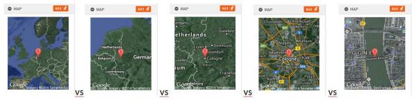 Diagram illustrating different zoom levels[/caption]
The real fun begins now. Thanks to Google, StreetView is available for many parts of the world. By using your maximum zoom level Geotag, and combining it with the StreetView panorama, suddenly you have the possibility of replicating the angle of the photograph to display the landmark both how it looked when the image was taken, and how it looks if not today then at least in the very recent past.
[caption id="attachment_964" align="alignnone" width="600"]
Diagram illustrating different zoom levels[/caption]
The real fun begins now. Thanks to Google, StreetView is available for many parts of the world. By using your maximum zoom level Geotag, and combining it with the StreetView panorama, suddenly you have the possibility of replicating the angle of the photograph to display the landmark both how it looked when the image was taken, and how it looks if not today then at least in the very recent past.
[caption id="attachment_964" align="alignnone" width="600"]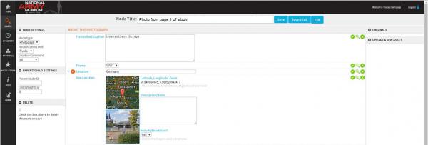 Your Geotag field gives the option to include StreetView imagery as well as a map[/caption]
[caption id="attachment_965" align="alignnone" width="600"]
Your Geotag field gives the option to include StreetView imagery as well as a map[/caption]
[caption id="attachment_965" align="alignnone" width="600"]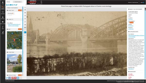 Original photograph taken during WWI with Geotag and Street View maps left. Click on the StreetView map…[/caption]
[caption id="attachment_966" align="alignnone" width="600"]
Original photograph taken during WWI with Geotag and Street View maps left. Click on the StreetView map…[/caption]
[caption id="attachment_966" align="alignnone" width="600"]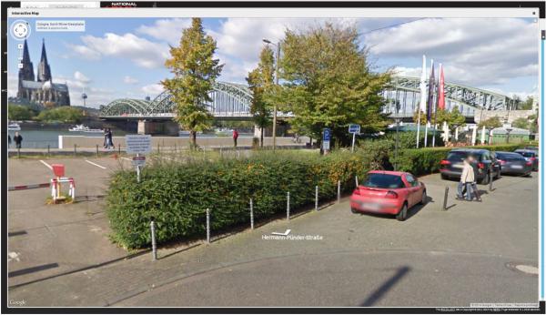 …and a window opens containing an interactive map. Here’s the same bridge today.[/caption]
[caption id="attachment_968" align="alignnone" width="600"]
…and a window opens containing an interactive map. Here’s the same bridge today.[/caption]
[caption id="attachment_968" align="alignnone" width="600"]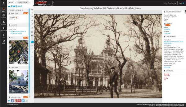 Another example – Synagogue, Capetown then and now[/caption]
Google has taken their StreetView cameras off the streets and actually inside some of the special places around the world. This means you can virtually walk through the likes of Pompeii in Italy, and Stonehenge in England. When I discovered a batch of portraits taken in Stonehenge, I was able to map almost the exact spot the portraits were taken.
[caption id="attachment_967" align="alignnone" width="600"]
Another example – Synagogue, Capetown then and now[/caption]
Google has taken their StreetView cameras off the streets and actually inside some of the special places around the world. This means you can virtually walk through the likes of Pompeii in Italy, and Stonehenge in England. When I discovered a batch of portraits taken in Stonehenge, I was able to map almost the exact spot the portraits were taken.
[caption id="attachment_967" align="alignnone" width="600"]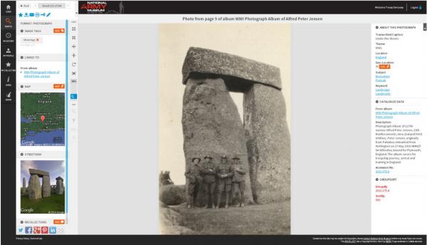 Stonehenge then and now[/caption]
Why is Geotagging important?
In my opinion, it enhances the connection to the past, it helps to cement the idea that these abstract images relate to real experiences by real people in real places. It can spark interest or discovery of new places and peoples, so can make a great teaching tool for primary and secondary teachers of history and geography. It also adds a whole new layer of knowledge – for example military historians may be able to pinpoint names like ‘Hill 63’ on a map of Belgium to allow those of us with limited or lesser understanding to learn more about the geography of the Western Front in WW1.
Finally it brings a new level of engagement by the members of your Recollect site. It’s a fun and rewarding task that can be done anywhere, anytime, by any one of your trusted members or editors (your choice) and is one of those activities that is likely to be shared as a ‘cool thing to do’. If you haven’t tried Geotagging on your own site yet, I suggest you give it a try. But, due to its addictive nature, perhaps meet that pressing deadline first.]]>
Stonehenge then and now[/caption]
Why is Geotagging important?
In my opinion, it enhances the connection to the past, it helps to cement the idea that these abstract images relate to real experiences by real people in real places. It can spark interest or discovery of new places and peoples, so can make a great teaching tool for primary and secondary teachers of history and geography. It also adds a whole new layer of knowledge – for example military historians may be able to pinpoint names like ‘Hill 63’ on a map of Belgium to allow those of us with limited or lesser understanding to learn more about the geography of the Western Front in WW1.
Finally it brings a new level of engagement by the members of your Recollect site. It’s a fun and rewarding task that can be done anywhere, anytime, by any one of your trusted members or editors (your choice) and is one of those activities that is likely to be shared as a ‘cool thing to do’. If you haven’t tried Geotagging on your own site yet, I suggest you give it a try. But, due to its addictive nature, perhaps meet that pressing deadline first.]]>